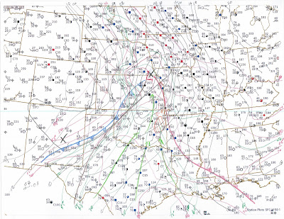
Synopsis:
An early fall trough is in the process of ejecting from the rockies and will continue to translate east across the southern plains today.
Storm Mode and Timing:
Expect storms to fire in NE OK most likely on a Tulsa to Mcalester line around 2PM this afternoon. Storms that fire in the early to mid afternoon have a chance of staying discrete and may be super cellular in nature. Storms should quickly form a squall line by early evening.
Target:
Muskogee, OK
Discussion:
Timing is against us on this system as the cold front to our NE is essentially one with the dry line. at 16Z the cold front stretches from eastern KS to the SW entering OK around the Ponca City area and stretching to the SW. Morning convection continues in far SE OK, with broken to overcast skies across eastern OK. The exception seems to be a clear slot to the south of Tulsa. Expect this clear slot to be the focus of heating and most likely the area that will initiate convection in the early to mid afternoon.
Td's in the upper 60's to low 70's are being driven by a 50+kt LLJ. This moist area will support CAPE values in the 2000 range in southeastern OK and eastern AR. Unfortunately, winds at the surface are veered and the main body of the upper level support is to the north and west of eastern OK. While storms will fire, the largest threat will be wind and hail. There is the possibility of an isolated tornado or two, but the dynamics are not there for any type of an outbreak.
Expect whatever convection that does fire this afternoon to quickly turn into a squall line by early evening and rapidly push to the east and southeast overnight. Again, the main threats will be hail and high winds.


