
Saturday, December 5, 2009
Thursday, December 3, 2009

Tuesday, December 1, 2009

Monday, November 30, 2009

Thursday, October 1, 2009
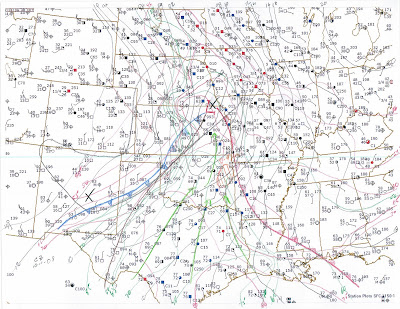
Forecast 10-1-2009
12Z 500mb
12Z 200mb
 12Z 700mb
 12Z 850mb
 12Z Surface

 12Z 700mb
 12Z 850mb
 12Z Surface
Synopsis:
An early fall trough is in the process of ejecting from the rockies and will continue to translate east across the southern plains today.
Storm Mode and Timing:
Expect storms to fire in NE OK most likely on a Tulsa to Mcalester line around 2PM this afternoon. Storms that fire in the early to mid afternoon have a chance of staying discrete and may be super cellular in nature. Storms should quickly form a squall line by early evening.
Target:
Muskogee, OK
Discussion:
Timing is against us on this system as the cold front to our NE is essentially one with the dry line. at 16Z the cold front stretches from eastern KS to the SW entering OK around the Ponca City area and stretching to the SW. Morning convection continues in far SE OK, with broken to overcast skies across eastern OK. The exception seems to be a clear slot to the south of Tulsa. Expect this clear slot to be the focus of heating and most likely the area that will initiate convection in the early to mid afternoon.
Td's in the upper 60's to low 70's are being driven by a 50+kt LLJ. This moist area will support CAPE values in the 2000 range in southeastern OK and eastern AR. Unfortunately, winds at the surface are veered and the main body of the upper level support is to the north and west of eastern OK. While storms will fire, the largest threat will be wind and hail. There is the possibility of an isolated tornado or two, but the dynamics are not there for any type of an outbreak.
Expect whatever convection that does fire this afternoon to quickly turn into a squall line by early evening and rapidly push to the east and southeast overnight. Again, the main threats will be hail and high winds.
Wednesday, August 26, 2009
Forecast 8/26/09
Synopsis:

Discussion:
Very little upper level support for the system entering the forecast area as depicted in the graphic above. The storms to the west of Tulsa are making very slow progress to the east tonight. The main concern is heavy rain tomorrow, not severe weather tonight.
3Z (9PM CDT) Radar Image:

The most likely scenario is a chance of a bit of rain and thunder tonight and then training storms along the cold front tomorrow. Where the front decides to park will determine rainfall amounts. See the current surface map below.
3Z Meso Surface:

Secondary shot of cold air looks to be on track for Sunday after an awesome cool Friday and Saturday. Comments and questions are always welcome. Hope you enjoy the forecast...
An upper level trough is just northwest of the forecast area with a cold front along the same axis.
0Z 200mb:

Discussion:
Very little upper level support for the system entering the forecast area as depicted in the graphic above. The storms to the west of Tulsa are making very slow progress to the east tonight. The main concern is heavy rain tomorrow, not severe weather tonight.
3Z (9PM CDT) Radar Image:

The most likely scenario is a chance of a bit of rain and thunder tonight and then training storms along the cold front tomorrow. Where the front decides to park will determine rainfall amounts. See the current surface map below.
3Z Meso Surface:

Secondary shot of cold air looks to be on track for Sunday after an awesome cool Friday and Saturday. Comments and questions are always welcome. Hope you enjoy the forecast...
Tuesday, August 25, 2009
Forecast 8/25/09
Synopsis:


 The NAM, GFS and ECMWF are all in pretty good agreement that the cold front should be to the south of the forecast area by 7PM on Thursday. Look for a chance of early morning convection Thursday morning with clouds probably lingering in the area for most of the day.

The forecast area remains under an upper level trough for the next 36 hours with a cold front to the NW from a low centered over the OK panhandle running to the NE across KS, NE, IA, MN and WI. The cold front was clearly visible on satellite and dovetails nicely with the ridge to the NW.
200mb 12Z:

Surface 12Z: (Note 200mb overlay in light blue)

Discussion:
The strange weather continues for NE OK as what should be the dog days of summer have seemed more like late spring (not that I am complaining about that). Temperatures should be just below seasonal norms through Wed then we will see another cool down and a chance for rain. The ridge we are under should continue to translate east over the next 36 hours with a cool front approaching the region in the overnight hours on Wed. Note the 72 ECMWF 200mb chart below.
ECMWF 72 hour:
 The NAM, GFS and ECMWF are all in pretty good agreement that the cold front should be to the south of the forecast area by 7PM on Thursday. Look for a chance of early morning convection Thursday morning with clouds probably lingering in the area for most of the day.
Once we get Thursday's front out of the picture look for another trough and cold front to move into the area during the Sunday timeframe.
120 Hour ECMWF:

Overall we will be below seasonal norms for this time of year and should be able to enjoy temperatures in the mid 80's during the days with temperatures falling into the lower 60's overnight. Not bad for August in OK!
Wednesday, August 19, 2009
Forecast 8/19/09
Updated 17Z Analysis, new target area is Perry OK.

Synopsis:
An upper level trough sits just to the west and north of the forecast area with a stationary front along the same axis.
12Z 200mb Analysis:


Discussion:
A difficult forecast today with the chances for rain and severe weather through the next 24 hours but great difficulty in nailing down the scenario. The models and the Tulsa WFO blew the call on the crapvection this morning in the Tulsa area. All indicators were that it should have stayed just to the NW, however we have ongoing convection and rain through the late morning hours.
1530Z INX Radar:


The real challenge with this forecast is trying to get a handle on the severe threat later in the day. The RUC and NAM are showing CAPE values in excess of 2000Kjg this afternoon and evening with a CAP that should erode to our NW mid to late afternoon. The models are also showing decent shear to the NW and over the forecast area early evening to overnight. This combination should provide the ingredients for a severe scenario in the late afternoon and the early evening hours. The SPC has a 5% tornado risk just NW of the forecast area and based on the parameters in the latest model runs I agree with this assessment.
At this time the most likely scenario is storms will fire in south central KS in the afternoon and make a run at NE OK in this evening. The best chance for severe weather including tornadoes will be to the NW in the south central KS and north central OK region in the early evening hours. The severe threat should decrease to the south east of this area. My best guess at this time is the storms will stay discreet for a short time in the late afternoon and evening before lining out as an MCS headed for NE OK.
12Z Surface:

If I were chasing today (and the more I think about it, I just might be) I would probably pick somwhere between Wellington KS and Ponca City OK as a target around 20Z. With 0-3km helicity values up to 300, CAPE pushing 3000, LI around 10 and low LCL's, the target area should be prime. Td's in the upper 60's should provide plenty of fuel as long as we get some day time heating, but that is really in question at this point e.g. latest visable sat... http://www.rap.ucar.edu/weather/satellite/displaySat.php?region=ICT&itype=vis&size=small&endDate=20090513&endTime=-1&duration=0
All that said, due to the ongoing convection this morning and cool temperatures the models may be over doing instability and this forecast could bust in NE OK. Conditions will need to be monitored throughout the day as they evolve. Long story short, if the sun breaks through this afternoon we may be in for it tonight...
12Z 500mb:
 12Z 700mb:
 12Z 850mb:
Tuesday, August 18, 2009
Forecast 8/18/09
An upper level trough lies just to the NW of the forecast area and should translate east over the next couple of days. A stationary front lies just to the N of the forecast area and has been the focus of ongoing convection.
12Z 200mb analysis

Discussion:
15Z Meso Surface

The overnight convection is ongoing to the W and N of the Tulsa area and has shown a weakening trend over the last few hours. An area of high pressure over NE OK is holding the convection off to the west and keeping the stationary front just to the N of the forecast area. Overcast skies due to debris from the convection to our west will hold temperatures down today and keep the chances of severe whether pretty much in check. There will be the possibility of hit or miss rain during the afternoon, but the best chances should stay to the north and west of Tulsa.
The best chance for rain appears to be in the Wednesday night time frame as the atmosphere should recover some instability during the day tomorrow. Shear should also increase during the late afternoon and evening hours Wednesday. At this time I am expecting an MCS to form to our NW during the late afternoon hours on Wed and enter the Tulsa area late in the evening. While there is the potential for some severe storms, rain should be the main mode for this complex.
Things should clear out after Wednesday and temperatures this weekend look to be at or below seasonal norms. While there is not a great agreement among the models at this time, it looks like temperatures may ramp up early next week with generally dry conditions prevailing.
12Z Regional Surface:
 12Z 850mb
 12Z 700mb
 12Z 500mb

 12Z 850mb
 12Z 700mb
 12Z 500mb
Monday, August 17, 2009


Forecast 8/17/09
Synopsis:
NW Flow remains just N of the forecast area with an upper level low centered over NW North Dakota. A stationary front runs from a surface low over the OK/TX panhandles to the NE into the upper mid west.
Surface 12Z

Discussion:
Overnight convection has been able to sustain through the morning hours just to the south of the stationary front. North central OK saw rain fall amounts in excess of 6" overnight with some damaging winds in the Enid area. The stationary front is progged to move slowly south over the afternoon and evening hours. However, the best area of shear will remain to the NW of the forecast area. An out flow boundary from the overnight convection lies over Osage county to the NW of Tulsa and has been making slow progress to the SE of the last few hours. Depending on where the boundary ends up, it should serve as the focus for additional convection this afternoon in the forecast area.
The shear environment should improve near the Tulsa area during the late afternoon hours after 21Z. If the out flow boundary makes it far enough south there is a good chance for scattered severe storms during the late afternoon and evening hours. The unknown at this point is whether the day time heating potential will be realized due to the high clouds from the morning convection. If the clouds manage to clear out in the next couple of hours the chance for storms will increase.
I know there are a lot of "ifs" in the above, but that is just how it goes with late summer thunderstorm forecasting...
700mb 12Z
 850mb 12Z
 200mb 12Z
Saturday, August 8, 2009
Forecast 8/8/09
Target Area:
Lake Wilson, MN
Timing:
20Z
Storm Mode:
All modes of convection are possible with super cell / multi cell favored late afternoon to early evening.
Synopsis:
An upper level ridge is centered over the target area per the 12Z soundings. Winds at 200mb are WSW at ~80kts. There is a surface low centered on KSFD as of 18Z with a warm front extending to the ENE on a line from KSFD to, Redwood falls MN, Glenwood City WI, then to the ESE. There is a trough of low pressure extending from the surface low to the N and extending from the surface low to the SSW according to a 17Z hand analysis.

Discussion:
Convection is ongoing to the W of the target area as of 18Z with one cell already warned to the W of KSFD. The RUC shows very little movement in the surface low over the next 12 hours. The low should continue to slide ENE along the nearly stationary warm front over the target area. The latest RUC runs show a trend to keep surface winds backed through 22Z in SW MN. With CAPE values in excess of 3000Jkg and 0-3km helicity values over 100 the atmosphere is certainly primed for potentially serious convection through the late afternoon and evening hours.
The activity should continue into the evening moving through an environment with sustained shear and an excellent inflow of 70+Td's from the SE. Deep moisture is available with 850mbTd's approaching 70 over southern MN according to the 12Z RUC run. 700mb temps are progged to be in the 12 degree range at 20Z, however given the convection to the west, the trough of low pressure and the warm front, there should be plenty of forcing available to break the cap with CinH values falling to -50 by 21Z.
18Z Surface (Don't have a scanner at the house for my hand surface analysis so here is one from DA)

Friday, August 7, 2009
Forecast 8/7/2009
Synopsis:


An upper level ridge has finally setup over the high plains. The extended ECMWF tries to keep the ridge in place over the next week but hints that it may sink south again before retreating to the north later next week.
Discussion:
The stationary front that provided the cool off the last couple of days has finally washed out and left the area under an area of high pressure. Temperatures will ramp throughout the weekend and dew points will stay up creating steamy conditions for the forecast area. Do not expect any rain chances through the weekend.
The real question is what happens next week. If the ridge is able to sink south early next week we should see seasonal conditions with highs in the mid 90's. However, if the ridge fails to retrograde, temperatures may get out of hand again. Either way, the ECMWF is trying to establish a full on omega block for late next week which will probably send temperatures above seasonal norms. Will need to monitor the upper level flow over the next couple of days to get a better handle on the extended forecast.
12Z 200mb

12Z Surface

Tuesday, August 4, 2009
Forecast 8/4/2009
Much like football, weather is a game of inches or miles as it may be. We are still sitting under NW flow that is quickly transitioning to an upper level ridge. It is going to be a hot and miserable next week or so. There is no real relief in the long range models at this point. Unless there is a big surprise I would plan on 101-95+ daytime highs with little or no precip for the next 7-10 days. I guess that is August in OK.
Just to share how close we came to relief take a look at the graphic below. It is the base radar scan from KINX tonight. There is a very well defined outflow boundary from earlier convection just SE of Bartelsville. That may serve as the focus for some storms tonight, but it looks like the better energy and setup are off to our NE here in Tulsa.
Keep the AC on and pray for relief in September....
3:26 KINX Radar

12Z Surface

12Z 850mb
 12Z 700mb
 12Z 500mb
12Z 200mb

Target Area 8/4/2009
Target: Bridgeport, NE
18Z RUC 200mb:
18Z Surface Analysis:
 The SPC is calling for a 5% chance for tornadoes across eastern WY and western NE and SD this afternoon. I am dubious as to whether this will verify but thought it was worth doing a bit of analysis. There is a pronounced trough of low pressure in eastern WY as depicted in the 18Z surface observations in the graphic above. This trough should translate east across western NE later this afternoon. Dew points in and to the east of the target are still in the mid to upper 50's which while not good storm material by OK standards, is plenty to get something going on the high planes. An area of ~1000kg-1 CAPE is forecast over far western NE according to the 18Z RUC run. While the hodographs are not very impressive, there is a decent amount of shear for any storms that fire to work with.

Timing and Storm Mode:
Late afternoon, 4PM CDT. Scattered convection, possible super cells.
Synopsis:
NW flow aloft over the target area with a cold front running to the SE. A trough of low pressure will move out of eastern WY into western NE.

Discussion:
 The SPC is calling for a 5% chance for tornadoes across eastern WY and western NE and SD this afternoon. I am dubious as to whether this will verify but thought it was worth doing a bit of analysis. There is a pronounced trough of low pressure in eastern WY as depicted in the 18Z surface observations in the graphic above. This trough should translate east across western NE later this afternoon. Dew points in and to the east of the target are still in the mid to upper 50's which while not good storm material by OK standards, is plenty to get something going on the high planes. An area of ~1000kg-1 CAPE is forecast over far western NE according to the 18Z RUC run. While the hodographs are not very impressive, there is a decent amount of shear for any storms that fire to work with.
I like Bridgeport as a target area for a couple of reasons. The first is there is a decent road network there and I believe storm motions will be to the SE. That should put the target downstream of most of the action and allow for easy repositioning as the afternoon unfolds. Second, I like the higher Td's in the area. The further north you go the lower the Td's. If anything does fire, I think the southern portion of the SPC area has the best chance of something tornadic. Finally, I like the position of the cold front just to the south of the target. The cold front isn't progged to move much in the next 12 hours, however as the area reaches maximum heating in the late afternoon, the cold front may serve as a lifting mechanism to help fire the convection.
Overall, I am not impressed with this setup, but keeping at forecasting is what I hope will improve my skills over time.
Finally, here is a shot of the current radar and surface front positions according to GRLevel3.

Monday, August 3, 2009
Forecast 8/3/2009
It looks like my previous entry last Thursday signaling an end to the cool weather was on target. I will sum up the forecast for those that don't want to read the whole thing, it is going to be hot for the next couple of weeks!


12Z Surface
 12Z 850mb
 12Z 700mb
 12Z 500mb

Synopsis:
NW flow aloft continues over the southern plains for another day before an upper ridge begins to shift east then north over the coming week. There are a couple of weak cold fronts over the high plains that will make a run at the area over the next couple of days, but should pass to our north and east.
Discussion:
While the last couple of weeks have been marked by cooler than normal temperatures and the passing of a cold front every couple of days, that is all about to change. The wind in the upper atmosphere at 200mb continues from the NW at this time, but is progged to turn into a "death ridge" over the high planes in the coming days.
12Z 200mb Hand Analysis:

If you note the light blue shaded lines you will see that the jet stream is building a ridge that is currently centered over eastern CO. Over the next few days the ECMWF is progging the ridge east then north. Note the 8/3 0Z ECMWF pretty much matches up with my hand analysis from this morning.
8/3/09 0Z 200mb ECMWF:

The really bad news is what happens to the ridge over the coming days. Note in the 8/7/09 0Z ECMWF run below that the ridge is sitting up over the high plains and a high is centered over southern TX.
8/7/09 0Z 200mb ECMWF:

The bad news is August is here and it should be everything that we expect August to be, hot, humid, and not very much chance of precipitation. Looking at the 168 hour ECMWF there is a chance that we could get a bit of a break early next week, but it doesn't look hopeful at this time. The long range GFS models seem to go nuts beyond 168 hours which makes me think the model doesn't have a very good handle on the situation. Best advice is to stay inside for the next week...
12Z Surface
 12Z 850mb
 12Z 700mb
 12Z 500mb
Subscribe to:
Comments (Atom)